ANY CALCULATOR HORIZONTAL SUNDIAL SHADOW ANGLE CALCULATOR
To find the Horizontal Sundial shadow hour angles
for your locality you need to know your latitude.
In the US the latitude can be found by reference to an
Ordnance Survey map. This will give your latitude in
units of degrees and minutes. Convert this angle to
decimal degrees before typing in to the first box below,
i.e. if your latitude is 53 30', type it in as 53.5
Then click the calculate button to see the results...
Sundial time = 12 Noon
Sundial time = 11:45 am and 12:15 pm
Sundial time = 11:30 am and 12:30 pm
Sundial time = 11:15 am and 12:45 pm
Sundial time = 11:00 am and 1:00 pm
Sundial time = 10:45 am and 1:15 pm
Sundial time = 10:30 am and 1:30 pm
Sundial time = 10:15 am and 1:45 pm
Sundial time = 10:00 am and 2:00 pm
Sundial time = 9:45 am and 2:15 pm
Sundial time = 9:30 am and 2:30 pm
Sundial time = 9:15 am and 2:45 pm
Sundial time = 9:00 am and 3:00 pm
Sundial time = 8:45 am and 3:15 pm
Sundial time = 8:30 am and 3:30 pm
Sundial time = 8:15 am and 3:45 pm
Sundial time = 8:00 am and 4:00 pm
Sundial time = 7:45 am and 4:15 pm
Sundial time = 7:30 am and 4:30 pm
Sundial time = 7:15 am and 4:45 pm
Sundial time = 7:00 am and 5:00 pm
Sundial time = 6:45 am and 5:15 pm
Sundial time = 6:30 am and 5:30 pm
Sundial time = 6:15 am and 5:45 pm
Sundial time = 6:00 am and 6:00 pm
Lat 34.8029 or 34d 48' 10.44" 4 Deg West Declination
Draw a line from A through the vertical line so that angle B'AB is equal to the latitude of the place where the dial is to be used. Remember this angle for making the gnomon.
All that is left is to add the gnomon and set the dial in the sun. The gnomon is a triangular piece that has one angle equal to the latitude of the place where the dial is to be used. See the diagram below on how to afix the gnomon to the dial.
It's now time to take the dial outside and start to tell time. Orient your dial so that the 12:00 hour line and gnomon (which lies along the 12:00 line) are pointing toward TRUE NORTH.
If you live in the Northern hemisphere finding true north is as easy as finding the North star and setting your dial to point at it, also if you measure the angle of the North star (Polaris) above the horizon you will have your latitude. DO NOT use a compass to find north, a compass shows magnetic north NOT true north.
What is North?
True North: (also known as Geographic North or Map North) is the geographic north pole where all longitude lines meet. All maps are laid out with true north directly at the top. Unfortunately for the wilderness traveler, true north is not at the same point on the earth as the magnetic north Pole which is where your compass points.
Magnetic North: Think of the earth as a giant magnet (it is actually). The shape of the earth's magnetic field is roughly the same shape as the field of a bar magnet. However, the earth's magnetic field is inclined at about 11° from the axis of rotation of the earth, so this means that the earth's magnetic pole doesn't correspond to the Geographic North Pole and because the earth's core is molten, the magnetic field is always shifting slightly. The red end of your compass needle is magnetized and wherever you are, the earth's magnetic field causes the needle to rotate until it lies in the same direction as the earth's magnetic field. This is magnetic north (marked as MN on a topographic map). The picture below shows the magnetic lines for the United States. If you locate yourself at any point in the U.S., your compass will orient itself parallel to the lines of magnetic force in that area.
What's your Map Declination?
The first thing you need to know is where you are in relation to magnetic north. You can find this information by looking on your map legend. If you look at a map of North America you will see the line roughly marking 0° declination. If you are on the line where the declination is 0 degrees, then you don't have to worry about any of this, since magnetic north and map north are equivalent. If you are to the right of that line, your compass will point toward the line (to the left) and hence the declination is to the west. If you are to the left of the line, your compass will point toward the line (to the right) and hence the declination is to the east.
Adjusting Your Compass for the Local Declination:
Another way to deal with declination is to adjust your compass. Some compasses have an outer degree ring that can be unlocked either with a set screw or a latch. This allows you to reset the compass to account for declination. For example, if the declination were 14 degrees East, you could rotate the degree dial to the right so that the magnetic needle was pointing to 14 degrees instead of 360 degrees. Once you do this, you will no longer have to add or subtract for declination because your compass is aligned to true north. Now when the compass needle is inside the orienting needle, the compass bearing that you read off your compass will be in relation to true north instead of magnetic north. If you have a fixed-ring compass, you can mark the declination angle on the compass ring with a piece of tape.
The Equation of Time:
The graph of the Equation of Time. which converts Sundial time (local apparent time) to local mean time.
Values presented are averages and may be in error by 10-15 seconds in January and December of certain years.
The apparent motion of the Sun along the plane of the ecliptic is not regular. This non-uniform motion is caused by two things: 1)The Earth's orbit is not circular but elliptical and 2) the Earth's axis is tilted about 23 degrees from the ecliptic. Mean Solar time assumes that the orbit is circular that there is no tilt and everything is like "clockwork". However this is not the case, so a Sundial (which shows Real Solar time) differs from the Mean time by the Equation of Time. Since clocks and watches use Mean Solar Time there will be an apparent error between the time your watch reads and the time your dial reads.
Day JAN FEB MAR APR MAY JUN JUL AUG SEP OCT NOV DEC
1
-3:12
-13:33
-12:34
-4:08
+2:51
+2:25
-3:33
-6:16
-0:12
+10:05
+16:20
+11:11
2
-3:40
-13:41
-12:23
-3:50
+2:59
+2:16
-3:45
-6:13
+0:07
+10:24
+16:22
+10:49
3
-4:08
-13:48
-12:11
-3:32
+3:06
+2:06
-3:57
-6:09
+0:26
+10:43
+16:23
+10:26
4
-4:36
-13:55
-11:58
-3:14
+3:12
+1:56
-4:08
-6:04
-0:45
+11:02
+16:23
+10:02
5
-5:03
-14:01
-11:45
-2:57
+3:18
+1:46
-4:19
-5:59
-1:05
+11:20
+16:22
+9:38
6
-5:30
-14:06
-11:31
-2:40
+3:23
+1:36
-4:29
-5:53
+1:25
+11:38
+16:20
+9:13
7
-5:57
-14:10
-11:17
-2:23
+3:27
+1:25
-4:39
-5:46
+1:45
+11:56
+16:18
+8:48
8
-6:23
-14:14
-11:03
-2:06
+3:31
+1:14
-4:49
-5:39
+2:05
+12:13
+16:15
+8:22
9
-6:49
-14:16
-10:48
-1:49
+3:35
+1:03
-4:58
-5:31
+2:26
+12:30
+16:11
+7:56
10
-7:14
-14:18
-10:33
-1:32
+3:38
+0:51
-5:07
-5:23
+2:47
+12:46
+16:06
+7:29
11
-7:38
-14:19
-10:18
-1:16
+3:40
+0:39
-5:16
-5:14
+3:08
+13:02
+16:00
+7:02
12
-8:02
-14:20
-10:02
-1:00
+3:42
+0:27
-5:24
-5:05
+3:29
+13:18
+15:53
+6:34
13
-8:25
-14:19
-9:46
-0:44
+3:44
+0:15
-5:32
-4:55
+3:50
+13:33
+15:46
+6:06
14
-8:48
-14:18
-9:30
-0:29
+3:44
+0:03
-5:39
-4:44
+4:11
+13:47
+15:37
+5:38
15
-9:10
-14:16
-9:13
-0:14
+3:44
-0:10
-5:46
-4:33
+4:32
+14:01
+15:28
+5:09
16
-9:32
-14:13
-8:56
+0:01
+3:44
-0:23
-5:52
-4:21
+4:53
+14:14
+15:18
+4:40
17
-9:52
-14:10
-8:39
+0:15
+3:43
-0:36
-5:58
-4:09
+5:14
14:27
+15:07
+4:11
18
-10:12
-14:06
-8:22
+0:29
+3:41
-0:49
-6:03
-3:57
+5:35
+14:39
+14:56
+3:42
19
-10:32
-14:01
-8:04
+0:43
+3:39
-1:02
-6:08
-3:44
+5:56
+14:51
+14:43
+3:13
20
-10:50
-13:55
-7:46
+0:56
+3:37
-1:15
-6:12
-3:30
+6:18
+15:02
+14:30
+2:43
21
-11:08
-13:49
-7:28
+1:00
+3:34
-1:28
-6:15
-3:16
+6:40
+15:12
+14:16
+2:13
22
-11:25
-13:42
-7:10
+1:21
+3:30
-1:41
-6:18
-3:01
+7:01
+15:22
+14:01
+1:43
23
-11:41
-13:35
-6:52
+1:33
+3:24
-1:54
-6:20
-2:46
+7:22
+15:31
+13:45
+1:13
24
-11:57
-13:27
-6:34
+1:45
+3:21
-2:07
-6:22
-2:30
+7:43
+15:40
+13:28
+0:43
25
-12:12
-13:18
-6:16
+1:56
+3:16
-2:20
-6:24
-2:14
+8:04
+15:47
+13:11
+0:13
26
-12:26
-13:09
-5:58
+2:06
+3:10
-2:33
-6:25
-1:58
+8:25
+15:54
+12:53
-0:17
27
-12:39
-12:59
-5:40
+2:16
+3:03
-2:45
-6:25
-1:41
+8:46
+16:01
+12:34
-0:47
28
-12:51
-12:48
-5:21
+2:26
+2:56
-2:57
-6:24
-1:24
+9:06
+16:06
+12:14
-1:16
29
-13:03
-12:42
-5:02
+2:35
+2:49
-3:09
-6:23
-1:07
+9:26
+16:11
+11:54
-1:45
30
-13:14
-4:44
+2:43
+2:41
-3:21
-6:21
-0:49
+9:46
+16:15
+11:33
-2:14
31
-13:24
-4:26
+2:33
-6:19
-0:31
+16:18
-2:43
Day JAN FEB MAR APR MAY JUN JUL AUG SEP OCT NOV DEC
Format of data is: [(+/-) minutes:seconds] where + is fast and - is slow.
The sun's motions
There are two motions made by the sun, both of which have an effect on the design of a sundial. The first is the apparent motion of the sun across the sky each day as the Earth rotates on it's axis. The second is the apparent motion of the sun across the celestial sphere each year as the Earth revolves about the sun. Notice that these motions are described as "apparent". The sun does not actually move but only "appears" to move due to the Earth's daily and yearly motions.
To measure the apparent motions of the sun, let us first define a base line from which the sun's position is measured. This base line is known as the local meridian and is a line extending from the north pole, through the location of the sundial, to the south pole. This meridian also projects from the surface of the Earth to the celestial sphere and describes an arc that extends from the north celestial pole, through the zenith, to the south celestial pole.
When the center of the sun crosses the local meridian, it is said to transit. The moment of transit is called local apparent noon. The time between two consecutive transits is equal to 24 hours. Since the sun travels through 360 degrees in this time it can be seen that the sun moves through 15 degrees every hour or 1 degree every four minutes. We will use this 15 degree value in laying out the lines on our dial.
A dial designed in such a manner will faithfully and accurately tell us local apparent time. The dial however, was designed before the advent of time zones and daylight savings time which explains, in part, why the dial did not agree with my watch. The instructions for making your dial include corrections for both time zones and daylight savings time.
A third factor is know as "the equation of time".
The Equation of Time
The sun's apparent motion across the celestial sphere in the course of a year is not uniform in its rate of travel. This is caused by two factors:
First, the Earth's orbit is not circular, but elliptical with the sun being at one of the foci. The Earth, and thus the apparent motion of the sun, varies in speed as it revolves around the sun. The speed is fastest at perihelion (closest approach to the sun), and slowest at aphelion (furthest distance from the sun). Perihelion occurs around January 4th. This variation in the sun's apparent speed is roughly sinusoidal and repeats once per year.
Second, the Earth is inclined (tilted) with respect to the plane of its orbit by about 23.5 degrees. This inclination causes the sun, at transit, to appear at it's highest point in the sky on June 21st and it's lowest point on December 22nd. These two points in the sun's annual motion are called the Summer Solstice and Winter Solstice respectively. When the sun is halfway between the solstices on March 21st and September 22nd, the points are called the Vernal Equinox and Autumnal Equinox respectively, At the equinoxes the sun is moving at it's fastest rate in its north-south travels. At the solstices, it's north-south travel slows to zero before reversing direction. This changing of speed and reversal in the north-south direction affects the sun's apparent speed as it circles the celestial sphere. This also is roughly sinusoidal and repeats twice each year.
The algebraic sum of the speed variations caused by an elliptical orbit and the Earth's tilt result in a sundial being sometimes fast and sometimes slow when compared to a clock. A clock, by the way, follows what is called the "mean sun"; a fictitious sun that travels across the celestial sphere at the equator. The mean sun travels at a rate equal to the average speed of the apparent sun. The apparent sun and the mean sun agree only four times each year. It is only at those four times that a sundial and a clock will agree. Any other time, there is a difference between sundial time and clock time. This difference is the equation of time.
In summary, three things account for the difference in time shown on a sundial and that of a clock: (1) Time zones (2) Daylight savings time (3) The equation of time
When these three factors are applied to a well designed sundial, its accuracy becomes such that one can set their watch by it to within one or two minutes.
The essential parts of a sundial.
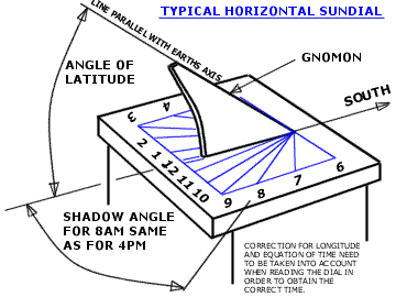
In its simplest form a sundial really only consists of two parts: One part casts a shadow, and the other part is a surface upon which the shadow falls. Given this simple definition, sundials have occured naturally since the creation of the world. The shadow of a tree on the ground or the shadow of a mountain in the valley below are two examples of naturally occuring sundials. Natural sundials can only provide a very rough indication of the age of the day. To gain precision and accuracy, the two essential parts of the sundial have been refined over the centuries. The shadow casting part of the horizontal dial is called the gnomon, while the part that receives the shadow is called the dial plate or face.
The gnomon
The gnomon is the part of the dial that extends into a vertical plane above the horizontal face of the dial. Gnomons for horizontal dials can be of many different shapes, from a simple rod to an intricately scrolled work of art. The most common mental image of a gnomon is that of a triangular piece that extends above the dial plate. The inclined or sloping edge of the gnomon is called the style. The style is the edge that cast the shadow onto the dial plate and is used to indicate the time. The angle the style makes with the face of the dial must be exactly equal to the latitude for which the dial is designed.
All gnomons have a nodus. The nodus is a specific point somewhere along the length of the style. In a simple triangular gnomon, the nodus is the uppermost point of the style. Sometimes a notch, bead or small horizontal bar is placed on the style to serve as the nodus. It defines a particular point on the shadow which is used with special lines on the dial face to indicate a multitude of information other than the time of day. The most common use of the nodus shadow is in conjunction with lines of declination on the dial plate to indicate the time of year. Other uses for the nodus shadow are to show special days of the year, the entrance of the sun into zodiacal constellations, sunrise and sunset in other cities, and the altitude and azimuth of the sun. A vertical line from the nodus to the dial plate is known as the perpendicular style. Both the style and the perpendicular style intersect the dial plate. A line drawn between these two points of intersection is called the substyle. A gnomon consists therefore of four basic parts; a style, a nodus, a perpendicular style and a substyle.
The dial plate
The dial plate is the flat, horizontal surface that receives the shadow of both the style and the nodus. The plate is marked with lines that the shadows move across to indicate time of day and time of year.
To create your own sundial use the hour line angle calculator at the top.
Print out the results, draw the angles on a card, similar to the image above.
Cut a gnomon at the same angle as your latitude then tape it standing on the 12 Noon line.
Find a place in the sun, point the gnomon north and you have a working sundial.
A permanent sundial can be constructed from wood or other durable materials.
Sine and Cosine Latitude Table
This table of sines and cosines of the latitude is needed for the construction of a horizontal or a vertical sundial for any latitude (except 0 or 90 deg).
Latitude
Sine
Cosine
1
0.017452
0.99985
2
0.034899
0.99939
3
0.052336
0.99863
4
0.069756
0.99756
5
0.087156
0.99619
6
0.10453
0.99452
7
0.12187
0.99255
8
0.13917
0.99027
9
0.15643
0.98769
10
0.17365
0.98481
11
0.19081
0.98163
12
0.20791
0.97815
13
0.22495
0.97437
14
0.24192
0.97030
15
0.25882
0.96593
16
0.27564
0.96126
17
0.29237
0.95630
18
0.30902
0.95106
19
0.32557
0.94552
20
0.34202
0.93969
21
0.35837
0.93358
22
0.37461
0.92718
23
0.39073
0.92050
24
0.40674
0.91355
25
0.42262
0.90631
26
0.43837
0.89879
27
0.45399
0.89101
28
0.46947
0.88295
29
0.48481
0.87462
30
0.50000
0.86603
31
0.51504
0.85717
32
0.52992
0.84805
33
0.54464
0.83867
34
0.55919
0.82904
35
0.57358
0.81915
36
0.58779
0.80902
37
0.60182
0.79864
38
0.61566
0.78801
39
0.62932
0.77715
40
0.64279
0.76604
41
0.65606
0.75471
42
0.66913
0.74314
43
0.68200
0.73135
44
0.69466
0.71934
45
0.70711
0.70711
The North Star is the last star in the handle of the Little Dipper.
The Little Dipper is a dimmer constellation, and not all of of its stars are visible from the city. The North Star and the last two stars of the bowl are usually visible. Note that the handle of the Little Dipper has the reverse curve of the handle of the Big Dipper.
The North Celestial Pole is the point in the sky about which all the stars seen from the Northern Hemisphere rotate. The North Star, also called Polaris, is located almost exactly at this point in the sky. If you go out at night and find the north star you will notice that it does not move during the course of the night, while all the other stars do move, they rotate from east to west around the north star.
You might wonder why this is important for building sundials. The Sun is also a star, so the Sun also rotates around the North Celestial Pole (Because we are so close to the Sun, the tilt of the Earth actually varies the exact axis of rotation of the Sun slightly away from the North Celestial Pole.) It is this rotation that will allow us to use the Sun to tell time.
We need to know where the North Celestial Pole is to use our sundials, but during the day, it is too bright to see the north star. How else can we know where to find this special place in the northern sky?
No matter where you live in the Northern Hemisphere there is an easy way to find the north star. As you might have guessed it is located due north, but how high in the sky is it? The north star is up from the horizon exactly an angle equal to your latitude. So if you live at 50 degrees latitude, the north star will be due north, up 50 degrees.
(An average person has about 10 degrees, from little finger to folded thumb, in a closed fist when held an arm's length away.)
The arrow you see pointing toward the North Celestial Pole in the diagram above is close to the axis about which the Sun rotates. All we need to do to make a well designed horizontal sundial tell time is to point the gnomon of the sundial along this axis. Then, as the Sun rotates around the gnomon it will cast a shadow onto our sundial surface where we will mark the appropriate hourlines. Both the angle of the gnomon and the position of the hourlines depend on the latitude where the sundial will be used.